Laugavegur Trail Hiking Guide for 2023
JUMP TO: PROS & CONS / ITINERARIES / CAMPSITES & HUTS / WHEN TO GO / GETTING THERE / MAPS / TRAILHEAD SERVICES / WHAT TO PACK
Author: Sam Brilleman | Updated: Mar 19, 2023
We may earn a commission when you buy through our links. Learn more.
Iceland's Laugavegur Trail is likely to be one of the most surreal hiking experiences you'll ever encounter. The scenery here is otherworldly. Sometimes so much so that it is hard to imagine how it came to appear on earth. It is a geological feast, with the main ingredient in this recipe being the volcanic underbelly of this little island.
At times, the hills appear to be liquid lava frozen in time (and that is because they are!). At other times, you'll cross plateaus of black volcanic ash that make you feel like you are taking a stroll on the moon. Walking down from the mountains on this hike can make you feel like a giant - with the valley carpet far below - and numerous perfectly shaped volcanoes popping up from the under the floor.
The volcanic landscape of Iceland appears quite surreal the first time you encounter it.
There is no other place on earth like Iceland, and the Laugavegur Trail gives you a 3-4 day hike that covers some of the most varied scenery in the country. Although the Laugavegur Trail is popular, it is with good reason. Consider combining the Laugavegur Trail with the 1-2 day Fimmvörðuháls Trail for one of the most rewarding hiking experiences on earth (crossing your fingers that you get good enough weather to reward you with the views!).
The Laugavegur Trail holds a special place in our hearts, as we believe it will yours!
Avoiding the middle of the peak season will mean far less hikers on the trail.
PROS
Amazing one-of-a-kind scenery in good weather!
Good hut system for if you don't like camping
No permits necessary but bookings are required for huts
Reliable public transport to trailheads
CONS
Temperamental weather
No scenery in bad weather!
Huts can be booked out in peak season (but campsites are usually available)
POSSIBLE ITINERARIES
The Laugavegur Trail is a 34 mile (55 km) one-way trail between Landmannalaugar and Thorsmork. On average it takes 3-4 days, but could be done in 2 days if you prefer long days on the trail. Most hikers then continue on from Thorsmork over the Fimmvorduhals pass to Skogar, which adds about 10 hours or 1-2 days of hiking.
Below, we describe the main features of these two trails. Note that the Icelandic Touring Association (Ferðafélag Íslands) provides a detailed route description for both the Laugavegur (see the section at the bottom of their webpage) and Fimmvorduhals trails.
We suggest taking your time, if possible. There are several small side trips that you can consider along the way. And you can even stay in Thorsmork a day or two to explore the local area, if you wish.
LAUGAVEGUR TRAIL
LENGTH: 34 miles / 55 km
DURATION: 3-4 days
TYPE: One-way
START: Landmannalaugar
FINISH: Þórsmörk (Thorsmork)
BEST TIME: Mid-July to mid-September
The 34 mile (55 km) Laugavegur Trail is the most popular multi-day hike in Iceland. You'll need to decide which direction you plan to hike and then arrange transport to the trailhead: either Landmannalaugar (northern trailhead) or Thorsmork/Skogar (the southern trailhead, depending on whether you will also hike the Fimmvorduhals Trail, more details below). If you don't have your own transport, then see our "How To Get There" section below for details about buses.
The Laugavegur Trail is usually traversed north to south. But in terms of geography there is no reason that it can't be traversed south to north. The northern trailhead at Landmannalaugar sits only 300 metres higher above sea level than the southern trailhead at Thorsmork, so your choice of direction has very little effect on the exertion required for the hike.
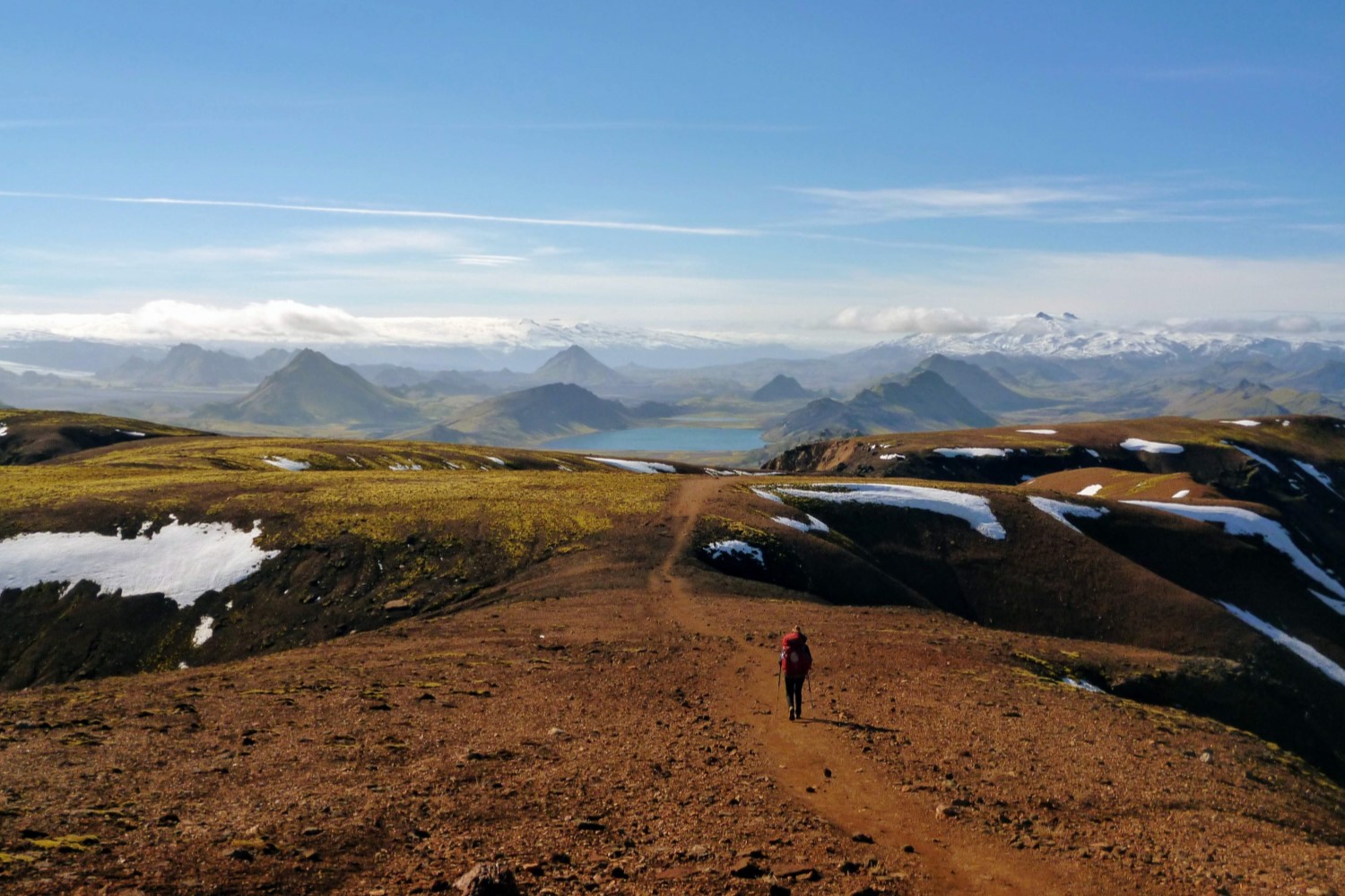
Travelling north to south has a slightly more intuitive feel for us, since you start up in the Icelandic highlands and walk south towards the coast. One benefit of this is - on your descent off the mountain plateau towards Alftavatn Hut - the views that open out in front of you are just astounding. On the other hand, if travelling south to north, you have the benefit of being able to enjoy the natural hot springs in Landmannalaugar at the conclusion of your hike!
Note however that during peak season hut bookings must be made north to south. So in peak season hiking south to north is only possible if you are planning on camping.
The views are stunning as the path ahead begins to open up on your approach towards Alftavatn Hut.
There are six huts along the trail, and you can choose which huts to stay at depending on the distances you plan to walk each day. The huts (travelling north to south) and distances between them are as follows:
Landmannalaugar to Hrafntinnusker: 12 km, 4-5 hrs
Hrafntinnusker to Álftavatn: 12 km, 4-5 hrs
Álftavatn to Hvanngil: 2 km, 1 hrs
Hvanngil to Emstrur: 14 km, 5-6 hrs
Emstrur to Thorsmörk: 15 km, 6-7 hrs
If you are staying in the huts, then you should book early (preferably several months in advance). If you are camping, then you need to camp at designated campsites located outside each hut. "Free camping" along the trail (between the huts) is not allowed. If you are camping, then reservations are optional - if you do not make a reservation then you can just pay the hut warden on arrival. See our "Campsites / Huts" section below for more info.
For the most part, the hike is undulating (except for the Fimmvorduhals Trail described below, which is very steep, if you choose to do it). Anyone with a reasonable level of fitness should be able to complete it. And the recommended time frame of 3-4 days amounts to relatively short days on the trail.
These old volcanic ash fields can make you feel like you're Buzz Aldrin walking back to Apollo 11.
The danger here is not the difficulty of the trail, rather, it is the weather. You need to make sure you are prepared. You must have a good waterproof jacket, and we also highly recommend good waterproof pants and gloves.
The scenery along the Laugavegur Trail is extremely varied, and - if you get good weather - you will be rewarded with mind-blowing views. But the volcanic highlands are also a harsh and relatively inhospitable place. So the views here are primarily of scenery rather than wildlife! Nonetheless it is scenery that is unrivalled. There is nowhere else on our special planet that is quite like this little volcanic island.
Note: When travelling between Hrafntinnusker and Álftavatn, consider the side trip up Háskerdingur, the highest peak in the area (1281m). It will take about 1-1.5 hours, and is worthwhile if time allows and the skies are clear.
In the right weather and light the colours along the trail can look quite spectacular.
FIMMVORDUHALS TRAIL
LENGTH: 15.5 miles / 25 km
DURATION: 8-10 hours (1-2 days)
TYPE: One-way
START: Þórsmörk (Thorsmork)
FINISH: Skogar
BEST TIME: Mid-July to mid-September
If possible, we highly recommend continuing on from Thorsmork to Skogar. Be warned though - the Fimmvorduhals Trail is not an easy hike - rather, it is a long and tough day. It includes over 1000 metres of ascent followed by 1000 metres of descent. And the trail passes between two glaciers and two active volcanoes. At times the earth can be rumbling under you and the sky closing in on top. Make sure you are prepared for both hard work and bad weather!
Many hikers complete it in a single day, taking about 8-10 hours. But if you'd prefer to take it easy, then consider booking a stay at one of the huts (details below). Generally speaking, in summer the trail doesn't require any specialist gear (e.g. crampons), but you do need to be prepared for all conditions. We recommend having full waterproof and windproof gear (i.e. jacket, pants, gloves).
As the Fimmvorduhals Trail ascends from Thorsmork, it begins to pass between two active volcanoes: the Eyjafjallajökull and Katla, each with their own glacial ice cap.
CAMPSITES AND HUTS
HUTS
The Icelandic Touring Association (Ferðafélag Íslands, FI) operates six huts along the Laugavegur Trail. They are generally open from mid-June to early-September, with the specific dates dependent on weather. Reservations for each of the huts should be made in advance. If you plan to travel in peak season, then you should consider booking several months in advance. In peak season hut bookings must be made from north to south. Bookings can be made through their enquiry form, via email, or by calling +354 568 2533.
The facilities at the huts along the trail keep improving every year. The latest information (July 2019) we have consists of the following.
SLEEPING: The huts provide "sleeping bag style" accommodation. So a basic mattress will be supplied, but you must bring your own sleeping bag and any other bedding you wish to have (e.g. pillow).
TOILETS & SHOWERS: All huts have flushing toilets, except Hrafntinnusker which has a latrine. Toilet paper and soap should be provided. All huts (except Hrafntinnusker) also have showers that can be used for a fee.
COOKING: Cooking facilities are provided for hut guests. This includes gas stoves, pots, pans, cooking utensils, and even dish liquid and tea towels! However these cooking facilities are only for hut guests and not for campers.
WATER: All huts will have running water that is safe for drinking.
HOT FOOD: A restaurant serving hot food can be found at each of Alftavatn and Thorsmork during the summer hiking season. Aside from these two restaurants, hot food is not available for purchase. Therefore you should plan on carrying your own food for cooking.
SUPPLIES: All huts sell some basic supplies (e.g. dried food, snack bars, gas canisters) but we don't recommend relying on them.
WARDENS: Each hut will have a warden working at it during the hiking season (i.e. whilst they are open). They are primarily there to handle reservations, but they can also assist you with route planning, suggested side trips, etc, as well as any emergencies or other issues you may encounter.
MORE INFO: More details on the huts can be found here and on the Laugavegur Trail huts FAQ.
In Hvanngil there is a hut that sleeps 60 people, as well as a sheltered campground inside an old lava field.
CAMPSITES
There is a designated campsite outside each of the six huts along the Laugavegur Trail (described above). You are not required to book campsites in advance — you can just show up and pay the warden on arrival. However if you feel more comfortable enquiring you can contact FI Huts using the enquiry form, via email, or by calling +354 568 2533.
The current cost (July 2019) for camping is 2000 ISK per person/night (approx US$18). The facilities for campers are described below.
TOILETS & SHOWERS: Campers have access to the same toilet facilities as described for the huts. You will also be able to use the showers for a fee if you wish.
COOKING: Campers do not have access to the kitchen facilities in the hut. You will therefore need to be self reliant — bring your own cooking stove, pots, etc. We found that even in stormy conditions the warden was not willing to let us cook our meal in the hut kitchen. Landmannalaugar, Emstrur and Thorsmörk huts do have common tents for campers to use as shelter when cooking, eating, or socialising, but the other huts do not.
WATER: At each hut campers have access to running water that is safe for drinking.
HOT FOOD: Campers can also access the restaurants serving hot food at Alftavatn and Thorsmork huts.
SUPPLIES: You will be able to purchase basic supplies from the hut warden.
MORE INFO: More details on camping can be found here.
The campsites are more spacious on the shoulder season!
FIMMVORDUHALS HUTS
The following only applies if you are adding on the extension from Thorsmork to Skogar (the Fimmvorduhals Trail, described above).
Many hikers complete this section in a single day, taking about 8-10 hours. But if you'd prefer to take it easy, then consider booking a stay at the Utivist-owned Fimmvorduhals Hut slightly west off the trail near the top of the pass (but book well in advance).
If the Fimmvorduhals Hut is all booked out, then another option worth investigating may be the unserviced FI-owned Baldvinsskali Hut, which was rebuilt in 2012. Until recently it didn't accept overnight reservations (but could still be used as an emergency shelter), however indications are that this may have recently changed.
If spending the night, then make sure you stock up on water before arrival, as there is no water supply at either of these huts. Note also that camping is not allowed on this section of trail, and wouldn't really be advisable anyway given the high altitude and temperamental weather of this mountain pass.
The picture below shows our final approach to the unserviced Baldvinsskali Hut, with gale-force winds, blizzard-like temperatures, and a whiteout setting in.
The Fimmvorduhals Pass can get treacherous weather any time of year, so make sure you are equipped for all conditions.
WHEN TO GO
The window available for hiking the Laugavegur Trail is small. And even smaller if you want to avoid the early summer snow melt and the peak summer crowds. The bus services to the starting point at Landmannalaugar run from approximately mid-June to mid-September (weather dependent). At other times of the year the roads to the highlands are impassable.
From mid-June to mid-August are the busiest times. This coincides with the slightly warmer weather and the near 24-hour daylight. However, during this peak period the huts can be full and bookings are recommended. If you are camping (our preference) then you generally don't need to book, but the campsites around the huts can be busy during peak season.
From mid-August onwards the nights get colder and darker, but the crowds begin to thin out. You may encounter the odd early snowfall (or snowstorm) and be wary that the huts are no longer serviced from around mid-September (although camping is still a viable option). But fewer people on the trail means that the second half of August is our preferred time for this hike.
Don't forget that the Icelandic highlands are known for their temperamental weather. Even in "peak summer" you might be unfortunate enough to encounter a whiteout or storm. That might mean a somewhat uninspiring (and potentially uncomfortable) hike. So always travel with an open mind and remember that nature offers no promises!
The start of the trail near Landmannalaugar is well formed, since it is a popular area for day-hikers too.
HOW TO GET THERE
FLIGHTS TO REYKJAVIK
A number of major airlines fly through Reykjavik — the capital of Iceland — on their Trans-Atlantic journey. In addition, several low-cost airlines offer cheap fares direct to Reykjavik from a number of major US, UK and European cities.
Reykjavik itself is a small but awesome city with great food, bars and people. So be sure to spend a little bit of time exploring some of the things to do in Reykjavik.
BUSES TO & FROM THE TRAILHEAD
Once you are ready to head on, you will need to arrange transport to Landmannalaugar for the start of the hike. There are three bus operators: Reykjavik Excursions, Sterna Travel and Trex.
COSTS (as at July 2019): The cost of a one-way fare between Reykjavik and Landmannalaugar is similar across the three providers (~ 8500 to 9000 ISK / US $67 to 77) but discounts are available if you book a return or round-trip ticket.
If you want a round-trip ticket taking you from Reykjavik to Landmannalaugar and then either Thorsmork to Reykjavik or Skogar to Reykjavik at the end of your hike, then consider buying one of the following passes:
Reykjavik Excursions “Iceland On Your Own” Hiking Pass (14000 ISK / US $111)
Sterna Highland Hikers Passport (13900 ISK / US $110)
Trex Hikers Bus Pass (15300 ISK / US $121)
Each of these passes allows you to complete two one-way trips on any of the three relevant routes, i.e.
Reykjavik — Landmannalaugar — Reykjavik
Reykjavik — Thorsmork — Reykjavik
Reykjavik — Skogar — Reykjavik
FLEXIBILITY & RESERVATIONS: Each provider recommends you make a reservation for a specific day & time so that you are guaranteed a seat. However all three providers allow flexibility if your plans change.
They have all stated (either on their website or via email correspondence) that you can just jump on the next bus if you finish your hike early or late. So you don’t necessarily need to panic if you are running late on your hike and miss your scheduled bus back to Reykjavik. Of course it is best if you can contact them to update your reservation though, when possible.
All three providers also allow you to jump on the next bus even if you do not have a booking. However those with a reservation will be given priority, so you will only be able to get on the bus if there is still space remaining once all the people with reservations are onboard.
FREQUENCY (as at July 2019): If you plan to hike from Landmannalaguar to Skogar, then the following gives you an idea of the frequency of each operator (of course we recommend you confirm these details on each providers website).
Between Reykjavik and Landmannalaugar the following applies:
Reykjavik Excursions are running two buses a day between (8am & 1pm)
Sterna are running one bus a day (7.15am)
Trex are running two buses a day (7.30am & 12.30pm)
Between Skogar and Reykjavik the following applies:
Reykjavik Excursions are running two buses a day (1.30pm & 6.30pm)
Sterna are running one bus a day (2pm)
Trex don’t actually operate a bus from Skogar to Reykjavik, but a Trex Hikers Bus Pass will get you on the Sterna bus (i.e. they share the service on this route).
So whether you can "hop on the next bus" passing through Skogar or Thorsmork at the end of your hike may depend on which operator you booked the round trip with. So you’ll need to balance cost and flexibility to decide what works best for you.
In any case, there is no need to rush back to Reykjavik after the hike! There are plenty of other amazing spots to see around Iceland. For example the renowned Vatnajökull Glacier (at Skaftafell) is only a few hours by bus to the east of Skogar. Or perhaps check out one of a number of unique places to stay in Iceland.
TRAVEL INSURANCE
Although hiking isn’t generally considered a high risk activity, accidents do happen! And they can be (very) expensive. So you might be considering travel insurance as part of your trip to Iceland.
World Nomads offers simple and flexible travel insurance. Most of their standard plans include cover for hiking and trekking up to the maximum elevations found in Iceland — but you’ll want to confirm that with them if taking out a policy, since the fine print differs based on your country of residence.
Plus, one upside of World Nomads is that they allow you to extend your insurance if you decide to extend your trip — something many other companies strangely don’t allow.
World Nomads provides travel insurance for travelers in over 100 countries. As an affiliate, we receive a fee when you get a quote from World Nomads using this link. We do not represent World Nomads. This is information only and not a recommendation to buy travel insurance.
"Well, I guess that any bridge is better than no bridge".
MAPS
There are several hiking maps covering this area. None of them are amazing, but they will do the job for the most part.
We used the Landmannalaugar, Porsmork, and Fjallabak Hiking Map published by Mal Og Mennig and it was fine. You can pick up at bookstores and other outlets (e.g. petrol stations) in Reykjavik. Or if you want it for planning beforehand then it is usually available through Amazon. It has 1:100,000 detail for the entire length of the Laugavegur and Fimmvorduhals Trails, as well as a 1:50,000 inset for just the Fimmvorduhals Trail. It has contour lines, but no grid squares. It wasn't waterproof, but I think they may publish a waterproof version. Our non-waterproof version weighed about 3.5 oz (100 grams).
A more recent alternative is the Iceland Hiking Map: Landmannalaugar, Laugavegur, Þórsmörk & Fimmvörðuháls published by Uwe Grunewald. It has 1:50,000 detail covering the entire length of the trail. It is printed on waterproof paper, weighs just 1.1 oz (30 grams), and has GPS points listed to help with navigation in poor visibility. It is also probably the cheapest map available. Although it has a better scale for hiking (1:50,000 instead of 1:100,000) it does lack grid squares, contour lines, and co-ordinates. You can purchase it online from the German site MapFox or Amazon. It is also available from a few stores in Europe, including some in Iceland. See the list at the bottom of the page on the publisher’s website here.
Another option is the Thorsmork / Landmannalaugar Map published by IDNU. It provides 1:100,000 detail for both the Laugavegur and Fimmvorduhals Trails. It can be purchased from the publisher, from the Iceland Touring Association, or from various other online retailers (type "IDNU Thorsmork Landmannalaugar map" into google).
The Laugavegur Trail is pretty well trodden and marked, so it is probably possible to walk the trail in peak season without a map. But we wouldn't recommend it! We always recommend carrying a trail map and compass. Beyond basic navigation, a map can also be useful for route planning, distance checking, water finding, identifying possible campsites, planning side trips, and more. Not to mention in case of bad weather, debatable junctions, emergency situations, improving your understanding of the area, and piece of mind.
Maps for the Laugavegur Trail can be found at bookshops and petrol stations in Reykjavik. Although the trail is well marked and pretty well trodden, we always suggest carrying a decent trail map...
TRAILHEAD SERVICES
LANDMANNALAUGAR
There are no services at Landmannalaugar aside from the hut, camping ground, and some hot springs (so bring your swimwear if you want!... although a hot bath isn't what I usually feel like at the start of a hike). Make sure you buy all your supplies before departing on the bus to Landmannalaugar.
THORSMORK
In Thorsmork there is a small shop selling very basic supplies. There are also several (basic) accommodation options. In addition to the usual Icelandic Touring Association (FI) hut several other commercial operators exist. The most notable of these is Volcano Huts who offer several types of basic accommodation as well as a buffet restaurant that serves hot food.
Volcano Huts also have a shower / sauna / bathing pool setup that can be accessed by non-residents for a small fee. This is a great option if you are camping or staying in the Icelandic Touring Association (FI) huts and just want to refresh & relax after your hike or before taking on the Fimmvorduhals Pass!
SKOGAR
There is camping available at Skogar, just near the base of the popular Skogarfoss waterfall (the finishing point for the Fimmvorduhals Trail). The campsite has a basic toilet block with showers. You just need to pay at the nearby Skogar HI Hostel.
If you are going to want a hot shower and proper bed on your arrival in Skogar then you have a few options. The Skogar HI Hostel has both dorms and private rooms. Alternatively, if you’d prefer something a bit more deluxe then both Hotel Skogar and Hotel Skogafoss are only a few minutes walk from the end of the trail.
There are also several guesthouses in Skogar. We stayed at Skogar Guesthouse and would highly recommend it. The owner's were lovely, the stay was comfortable, and they have a hot tub! There is also Þorsteinshús Four-Bedroom House — we’ve not stayed there ourselves but it has a good reputation.
But beware that Skogafoss waterfall is a popular attraction for car tourists, and Skogar is only a small village with limited options for accommodation. If you plan to stay, we suggest you book ahead. And note that prices can be high in peak season.
Also note that there is no supermarket in Skogar at the end of your hike. There are a couple of restaurants that serve food during meal times. However outside of standard meal times we found that food is pretty much unavailable in the village.
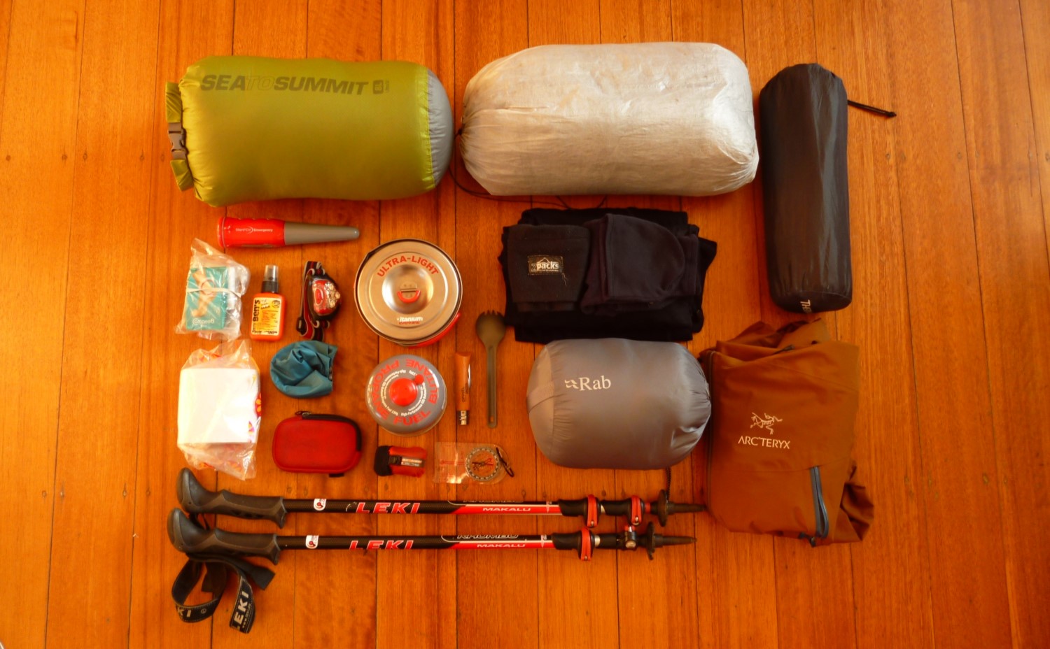
WHAT TO PACK FOR THE LAUGAVEGUR TRAIL
The weather in the Icelandic highlands can be very temperamental. Even in the peak summer season you need to be prepared for winds, rain, cold… and perhaps even snow. These are some of the essentials we recommend packing for your Laugavegur Trail hike.
Note: For more detailed reviews of some of the gear listed below check out our backpacking gear reviews and ultimate backpacking gear list.
WATERPROOF & WINDPROOF CLOTHING
You will need to carry a rain jacket and rain pants any time of year.
This is a must. You should not go hiking the Laugavegur Trail without a good quality waterproof and windproof jacket and pants.
Without both of these items you could suffer serious wind chill and hypothermia if the weather turns against you.
Some hikers think they can get through with just hiking shorts or hiking pants without the need for waterproof pants for layering on top. In some environments that can work fine. But in Iceland it isn’t a wise idea. Waterproof pants are a necessity for bad weather in Iceland.
Jacket: Our all-time favourite jacket is the Arc’teryx Beta LT — it is feature-rich, extremely durable, and seriously weatherproof. It is quite heavy for lightweight backpacking (12.2 oz), but we just love it and so are willing to carry the extra few ounces. But if you’d prefer something a bit more lightweight then consider the Arc’teryx Zeta FL (7.2 oz), Montane Minimus Jacket (7.5 oz), or Patagonia Storm Racer (6 oz).
Pants: Before buying waterproof pants you should decide what length zipper you want along the outside. Waterproof pants with ankle zippers are often the lightest, but they are sometimes difficult to get on over boots and have almost no ventilation. Full length or 3/4 length zippers are heavier, but they make it much easier to get the trousers on over your shoes or boots and they can be partly unzipped from the top to provide ventilation. We opt for the Berghaus Paclite Pants (8.0 oz, 3/4 length zipper), but the Mountain Hardwear Stretch Ozonic Pants (10.0 oz, full length zip) are another good option. If you want maximum weight savings, then the Outdoor Research Helium Pants (6.5 oz, ankle zipper) are the way to go.
Gloves or mittens: We also recommend packing waterproof gloves or mittens. You can probably survive a bad storm without them but you might be very uncomfortable. We carry a pair of fleece flip top mittens along with an waterproof shell mitten. The two best ultralight shell mittens currently available are the Montane Minimus Mitt (1.55 oz) and the Zpacks Vertice Rain Mitts (0.71 oz).
OTHER CLOTHING
It can get pretty chilly at the higher elevations, so pack warm clothing that allows you to layer.
For during the day you should pack clothing that allows you to layer. This helps with regulating your temperature as the weather changes. Items such as a warm hat and neck warmer also provide significant additional warmth for their weight.
For evenings and overnight on the Laugavegur Trail you should have an insulated jacket that will keep you comfortable down to freezing (i.e. 32°F / 0°C) or thereabouts.
The exact clothing you pack will depend on your personal preferences and backpacking style. If you are new to backpacking then we suggest the following:
Baselayer (underwear): For men we suggest the Smartwool Merino 150 Boxer Briefs (we carried two pairs). For women we suggest the Smartwool Merino 150 Bikini and Icebreaker Meld Zone Sports Bra.
Baselayer (for hiking): We opt for a merino t-shirt, specifically the Smartwool Merino 150 T-Shirt. We also carry a Smartwool Merino 250 Quarter-Zip Top for layering. It performs well and the zip allows us to regulate our temp.
Hiking trousers or shorts: We tend to use lightweight nylon convertible pants, like the Columbia Silver Ridge Convertible Pants. Although on the Laugavegur trail we didn’t really “convert” them much! Nonetheless, it is good to have the option to convert them to shorts if the weather does get warm.
The features I look for in hiking pants are: comfortable, lightweight, and quick drying. I also prefer an elastic waist with a drawstring, but some people prefer a belt. I like to have elastic around the ankles, so that I can easily wear them without shoes at camp and not have the cuffs drag on the ground. However, there aren’t many hiking pants sold with elasticated ankles — so this is usually a modification you would have to do at home.
Insulating jacket: Our favourite down jacket is the Rab Electron, but if you want something thinner and lighter then consider the Patagonia Micro Puff Hoody. If you’d prefer a synthetic jacket (they have a lower warmth-to-weight ratio, but retain warmth when wet) then our favourite is the Arc’teryx Atom AR Hoody.
Warm hat, gloves and neck warmer: We love the Zpacks Micro-Fleece Hat — its ultralight but still warm. For warm gloves we opt for a pretty generic Fleece Flip-Top Mitten. We also carry a Smartwool 150 Neck Gaiter — it provides significant warmth for its weight.
Hiking shoes: We use the La Sportiva Ultra Raptor Trail Running Shoes and love them. Although not waterproof, they are sufficient for the Laugavegur Trail. There are several unbridged river crossings on the Laugavegur Trail. They aren’t particularly deep, but your feet are likely to get wet above the ankle line. If you choose to wear Gore-Tex hiking shoes or boots (which do not dry easily) then you may need to also carry river crossing shoes.
Hiking socks: We use the Bridgedale Wool Fusion Ultralight Socks. You should choose socks that are relatively light and breathable, but will provide sufficient warmth for your personal preferences. We carry one pair for hiking and one pair for sleeping.
Additional baselayers for sleeping (top, pants, socks): You will want a spare pair of merino or synthetic thermal underwear for sleeping. We carry a pair of lightweight merino bottoms and merino long sleeve top. We suggest the bottoms as a minimum, but whether you take an additional long sleeve top just for sleeping might depend on your backpacking style. A spare pair of hiking socks can be used for sleeping. Alternatively, if you sleep cold, then PossumDown Bushman's Friend Socks or even Goose Down Booties are warmer options.
Camp shoes (optional): Some people like to carry a spare pair of lightweight sandals (or similar) for evenings in camp or in the huts. If you opt for this approach then we suggest choosing sandals that can also be used for stream crossings, since the Laugavegur Trail has several unbridged stream/river crossings that have water above ankle depth.
SHELTER & SLEEP SYSTEM
A tent with a large vestibule can make life easier in stormy weather.
You will need a good quality sleeping bag for the Laugavegur Trail, regardless of whether you plan to sleep in the huts or camp.
If you are camping then you will also need a sturdy reliable tent and a sleeping pad.
Sleeping bag: We think the Feathered Friends Lark is ideal for the conditions you will likely encounter on the Laugavegur Trail. It is rated to 10°F (-12.2°C). But sleeping manufacturers tend to dramatically exaggerate temperature ratings. We think the Lark is pretty comfortable down to about freezing (32°F / 0°C) or just below. If you want something a bit cheaper but still high quality then check out the REI Co-Op Magma 15°. Alternatively, if you want to go lightweight then consider a backpacking quilt.
Sleeping pad: We believe the best sleeping pads are inflatable air pads. They are lightweight and much more comfortable than traditional closed-cell foam pads. An inflatable air pad is ideal for the Laugavegur Trail where the ground is often hard, rocky, and unforgiving. Since conditions can get quite cold on the Laugavegur Trail, the Therm-a-Rest NeoAir XTherm would be our recommended pick. More info: Best Sleeping Pads.
Pillow: A backpacking pillow such as the Sea to Summit Aeros Premium can seriously improve your sleep quality and doesn’t need to weigh much. More info: Best Backpacking Pillows.
Tent: Your tent should be able to withstand high winds and heavy rains. Wardens at the huts are not always accommodating to campers — meaning that you may still need to cook and eat outside in bad weather (we were denied entry to the hut for cooking even in stormy weather). So a tent with a large vestibule that can be used for cooking is always useful. We do not recommend taking a tarp instead of a tent, as many of the campsites along the Laugavegur Trail are relatively exposed and can be subject to high winds. Our favourite tent is the Zpacks Triplex, but the Big Agnes Tiger Wall UL2 is another great lightweight option that is slightly cheaper. More info: Best Backpacking Tents.
BACKPACK & GEAR STORAGE
For the Laugavegur Trail most people will need a backpack with a total volume of between 40 and 60 litres. This will depend on whether you are camping or staying in huts and how lightweight or dialled in your backpacking gear is.
Traditional backpacks made with heavy frames and heavy materials are no longer necessary. Modern materials mean that lightweight backpacks can be just as durable and comfortable. Our favourite lightweight backpack is the Zpacks Arc Haul Zip — its ultralight, feature rich, and almost fully waterproof. More info: Best Backpacks.
We also use dry sacks to arrange most of the gear inside our backpack. The Sea To Summit Ultra Sil Dry Sacks are our favourites. They are ultralight, waterproof, and the colours are useful for sorting gear.
CAMP KITCHEN
Regardless of whether you are camping or staying in the huts, you will need to bring cooking equipment. The huts at Alftavatn and Thorsmork have seasonal restaurants, but do not rely on them!
Cooking equipment: We suggest packing a stove + fuel, lighter, cooking pot(s), and spork. And perhaps a bowl or cup (optional). More info: Ultimate Backpacking Gear List - Kitchen.
Water treatment: The water in the Icelandic Highlands is pretty pure, but we always suggest carrying water treatment of some form just in case. Our favourite is the SteriPEN Adventurer Opti. If you prefer a filter then the Sawyer Squeeze is a great lightweight option.
OTHER EQUIPMENT
The Laugavegur Trail is pretty well signposted and trodden, but we always recommend carrying a map & compass.
Map & compass: We always suggest carrying a map and compass — even though the Laugavegur Trail is pretty well signposted and trodden. See above for detailed info on maps. Our favourite compass is the Suunto M-3 D Leader.
Pocket knife: The Opinel No. 6 Stainless Steel Pocket Knife is our favourite — it is both cheap and reliable.
Headlamp: Our favourite is the Petzl Actik Headlamp.
Trekking poles (optional): We love them! And wouldn’t do a multi-day hike without them. They also serve as our tent poles. Check out the Leki Micro Vario Carbon for high-end quality, the REI Co-Op Flash Carbon for all round value, or the Gossamer Gear LT5 for ultralight.
Bathroom: Bug spray, toothbrush, toothpaste, soap (for hand washing), sunscreen, lip balm, toilet paper, blister plasters, first aid essentials, lightload pack towel (optional).
Electronics (optional): Camera, e-reader, GPS, personal locator beacon.
MORE INFORMATION
If you are heading to Iceland to hike the Laugavegur Trail, then our gear related content should help with your preparation:
Alternatively, if you enjoyed reading this destination guide then you'll likely love reading about other equally inspiring hiking destinations, such as:
Happy endeavours out on the trail!

Keen To Browse Outdoor Kit?
Check out our Gear Reviews overview page. Or focus in on one of these awesome review sections:
Ready To Start Building Your Dream Kit List?
In our Ultimate Gear Lists section we provide a list of best-in-class items for specific outdoor adventures. Get inspired by checking out our:
Gagging To Get To The Outdoors?
Find a jaw-dropping location for your next wilderness adventure by checking out our epic Destination Guides! How about: